
About Ukraine
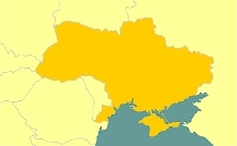
Ukraine is situated at the boundary between Central and Eastern Europe, on the north side of the Black Sea and the Sea of Azov. With a territory slightly larger than that of France, it is the largest country contained wholly within Europe.
Ukraine – Україна – means 'borderland', which refers to its historical and cultural position at the intersection of the Western/Catholic, Eastern/Orthodox and Southern/Muslim worlds. It also lies at the crossroads of historical east-west and north-south transport and trade routes.
In this section you can use your knowledge of the alphabet (and the word-recognition skills you acquired in the section on the Ukrainian language) to find out more about Ukraine – its geographical location, neighbouring countries, flag, state emblem and principal cities. Look at the illustrations in the slides and try to understand the Ukrainian texts as they appear in the animations. The English translation is also provided on the slides (so that you can check that you have understood correctly), as well as notes and a vocabulary list.